Showing posts with label Phillip_Island. Show all posts

Tuesday, 27 May 2025

SEAL ROCKS, PHILLIP ISLAND

Phillip Island is an Australian island about 140 km south-southeast of Melbourne, Victoria. Named after Arthur Phillip, the first Governor of New South Wales, Phillip Island forms a natural breakwater for the shallow waters of the Western Port. It is 26 km long and 9 km wide, with an area of about 100 km2. It has 97 km of coastline and is part of the Bass Coast Shire.

A 640 m concrete bridge (originally a wooden bridge) connects the mainland town San Remo with the island town Newhaven. In the 2011 census the island's permanent population was 9,406, compared to 7,071 in 2001. During the summer, the population swells to 40,000. 60% of the island is farmland devoted to grazing of sheep and cattle.

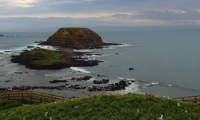
Seal Rocks, seen here, is a group of rocky inlets along Phillip island's coastline. They are home to Australia's largest fur seal population, numbering around 16,000. The population peaks between late October to December, but it is possible to view seals at all times of the year. Seals eat squid, cuttlefish and small fish. They can dive up to 100m and have excellent underwater vision.

This post is part of the Travel Tuesday meme


Tuesday, 26 April 2022

PHILLIP ISLAND, AUSTRALIA

Phillip Island is an Australian island about 140 km south-southeast of Melbourne, Victoria. Named after Arthur Phillip, the first Governor of New South Wales, Phillip Island forms a natural breakwater for the shallow waters of the Western Port. It is 26 km long and 9 km wide, with an area of about 100 km2. It has 97 km of coastline and is part of the Bass Coast Shire. The southern coast of the island lies exposed to the ocean of Bass Strait and can experience some wild weather, which doesn't seem to deter avid surfers.

This post is part of the Travel Tuesday meme,


Tuesday, 25 May 2021

PHILLIP ISLAND

Phillip Island is an Australian island about 140 km south-southeast of Melbourne, Victoria. Named after Arthur Phillip, the first Governor of New South Wales, Phillip Island forms a natural breakwater for the shallow waters of the Western Port. It is 26 km long and 9 km wide, with an area of about 100 km2. It has 97 km of coastline and is part of the Bass Coast Shire. A 640 m concrete bridge (originally a wooden bridge) connects the mainland town San Remo with the island town Newhaven.

In the 2011 census the island's permanent population was 9,406, compared to 7,071 in 2001. During the summer, the population swells to 40,000. 60% of the island is farmland devoted to grazing of sheep and cattle.

Seal Rocks, seen here, is a group of rocky inlets along Phillip island's coastline. They are home to Australia's largest fur seal population, numbering around 16,000. The population peaks between late October to December, but it is possible to view seals at all times of the year. Seals eat squid, cuttlefish and small fish. They can dive up to 100m and have excellent underwater vision.

This post is part of the Our World Tuesday meme,
and also part of the Travel Tuesday meme,
and also part of the Wordless Wednesday meme.


Tuesday, 25 February 2020

PHILLIP ISLAND

Phillip Island is an Australian island about 140 km south-southeast of Melbourne, Victoria. Named after Arthur Phillip, the first Governor of New South Wales, Phillip Island forms a natural breakwater for the shallow waters of the Western Port. It is 26 km long and 9 km wide, with an area of about 100 km2. It has 97 km of coastline and is part of the Bass Coast Shire.

A 640 m concrete bridge (originally a wooden bridge) connects the mainland town San Remo with the island town Newhaven. In the 2011 census the island's permanent population was 9,406, compared to 7,071 in 2001. During the summer, the population swells to 40,000. 60% of the island is farmland devoted to grazing of sheep and cattle.

This post is part of the Our World Tuesday meme,
and also part of the Travel Tuesday meme,
and also part of the Wordless Wednesday meme.

Tuesday, 30 October 2018

SUMMER COMMENCES

Phillip Island is an Australian island about 140 km south-southeast of Melbourne, Victoria. Named after Arthur Phillip, the first Governor of New South Wales, Phillip Island forms a natural breakwater for the shallow waters of the Western Port. It is 26 km long and 9 km wide, with an area of about 100 km2. It has 97 km of coastline and is part of the Bass Coast Shire.

A 640 m concrete bridge (originally a wooden bridge) connects the mainland town San Remo with the island town Newhaven. In the 2011 census the island's permanent population was 9,406, compared to 7,071 in 2001. During the summer, the population swells to 40,000. 60% of the island is farmland devoted to grazing of sheep and cattle.

Here is Cowes Beach. We are having fine, summery weather in Melbourne at the moment, with a maximum of 36˚ C expected next Thursday...

This post is part of the Our World Tuesday meme,
and also part of the Travel Tuesday meme,
and also part of the Wordless Wednesday meme.

Wednesday, 11 October 2017

NEWHAVEN, PHILLIP ISLAND

Newhaven is a town in southern Victoria, in the south Gippsland region, 126 km SE of Melbourne. Located on Phillip Island, adjacent to the channel known as The Narrows, it is the town on the island side of the concrete 640 m bridge linking Phillip Island to the mainland. At the 2006 census, Newhaven had a population of 428. The Post Office opened on 1 January 1873 and closed in 1975.

The town's economy is primarily based on retirement living and tourism, and has a fine Yacht Club with marina. Atlantis Nereus tidal turbines are installed at Newhaven. In 1980, Newhaven College was established and Newhaven Primary School has been situated in Newhaven for a great number of years.

This post is part of the ABC Wednesday meme,
and also part of the Outdoor Wednesday meme,
and also part of the Wordless Wednesday meme,
and also part of the My Town Shootout meme.


Wednesday, 19 April 2017

OCEAN AT PHILLIP ISLAND

Phillip Island is an Australian island about 140 km south-southeast of Melbourne, Victoria. Named after Arthur Phillip, the first Governor of New South Wales, Phillip Island forms a natural breakwater for the shallow waters of the Western Port. It is 26 km long and 9 km wide, with an area of about 100 km2. It has 97 km of coastline and is part of the Bass Coast Shire. The southern coast of the island lies exposed to the ocean of Bass Strait and can experience some wild weather, which doesn't seem to deter the avid surfers.

This post is part of the Wednesday Waters meme,
and also part of the Outdoor Wednesday meme,
and also part of the Wordless Wednesday meme,
and also part of the ABC Wednesday meme.


Monday, 3 October 2016

PHILLIP ISLAND

Phillip Island is an Australian island about 140 km south-southeast of Melbourne, Victoria. Named after Arthur Phillip, the first Governor of New South Wales, Phillip Island forms a natural breakwater for the shallow waters of the Western Port. It is 26 km long and 9 km wide, with an area of about 100 km2. It has 97 km of coastline and is part of the Bass Coast Shire.

A 640 m concrete bridge (originally a wooden bridge) connects the mainland town San Remo with the island town Newhaven. In the 2011 census the island's permanent population was 9,406, compared to 7,071 in 2001. During the summer, the population swells to 40,000. 60% of the island is farmland devoted to grazing of sheep and cattle.

This is part of the Monday Mellow Yellows meme,
and also part of the Blue Monday meme,
and also part of the Through my Lens meme,
and also part of the Seasons meme.


Sunday, 8 November 2015

CAPE BARREN GEESE

The Cape Barren goose (Cereopsis novaehollandiae) is a large goose resident in southern Australia, classified in the family Anatidae. The species is named for Cape Barren Island, where specimens were first sighted by European explorers.

These are bulky geese and their almost uniformly grey plumage, bearing rounded black spots, is unique. The tail and flight feathers are blackish and the legs are pink with black feet. The short, decurved black bill and light green cere gives it a very peculiar expression. The Cape Barren goose is 75 to 100 cm long, weighs 3 to 7 kg and has a 150 to 190 cm wingspan; males are somewhat larger than females.

This bird feeds by grazing and rarely swims. Their ability to drink salt or brackish water allows numbers of geese to remain on offshore islands all year round. They are one of the rarest of the world's geese. It is gregarious outside the breeding season, when it wanders more widely, forming small flocks.

A previous decline in numbers appears to have been reversed as birds in the east at least have adapted to feeding on agricultural land. The breeding areas are grassy islands off the Australian coast, where this species nests on the ground in colonies. It bears captivity well, quite readily breeding in confinement if large enough paddocks are provided. These photos were taken on Phillip Island, where large numbers of these geese may be seen.

This post is part of the Saturday Critters meme,
and also part of the Camera Critters meme.


Wednesday, 28 October 2015

THE NOBBIES, PHILLIP ISLAND

The Nobbies is a magnificent headland on the south-western tip of Phillip Island. Strolling along the boardwalks around The Nobbies, one can enjoy coastal views at lookout points set amongst natural sea bird gardens. Around one kilometre offshore from The Nobbies is Seal Rocks, home to Australia's largest colony of fur seals. These creatures can be seen as they sun themselves on the rocks, feed their young, wrestle, or flop into the cool water.

This post is part of the Wednesday Waters meme,
and also part of the Waterworld Wednesday meme,
and also part of the Outdoor Wednesday meme,
and also part of the Wordless Wednesday meme,
and also part of the ABC Wednesday meme.


Wednesday, 21 October 2015

PHILLIP ISLAND BEACH

Phillip Island is an Australian island about 140 km south-southeast of Melbourne, Victoria. Named after Arthur Phillip, the first Governor of New South Wales, Phillip Island forms a natural breakwater for the shallow waters of the Western Port. It is 26 km long and 9 km wide, with an area of about 100 km2. It has 97 km of coastline and is part of the Bass Coast Shire.

A 640 m concrete bridge (originally a wooden bridge) connects the mainland town San Remo with the island town Newhaven. In the 2011 census the island's permanent population was 9,406, compared to 7,071 in 2001. During the summer, the population swells to 40,000. 60% of the island is farmland devoted to grazing of sheep and cattle.

This post is part of the Wednesday Waters meme,
and also part of the Waterworld Wednesday meme,
and also part of the Outdoor Wednesday meme,
and also part of the Wordless Wednesday meme.