Showing posts with label beach. Show all posts

Tuesday, 6 May 2025

LAKES ENTRANCE

Lakes Entrance is a town in the Shire of East Gippsland, Victoria, Australia. It is situated approximately 320 kilometres east of Melbourne, near a managed, artificial channel connecting the Gippsland Lakes to Bass Strait. At the 2016 census, Lakes Entrance had a population of 4,810. The township was originally named Cunninghame, the Post Office of that name opening on 5 February 1870. It was renamed Lakes Entrance on 1 January 1915.

Lakes Entrance, which lies almost at sea level, can be reached from Melbourne via Bairnsdale (which can be acessed via train and bus from Melbourne), and the town of Kalimna to the north-west by a stretch of the Princes Highway, which snakes down and around a point protruding into the Gippsland Lakes known as "Jemmy's Point". Views of The Entrance and of the Lakes can be seen from various look-outs on Jemmy's Point.

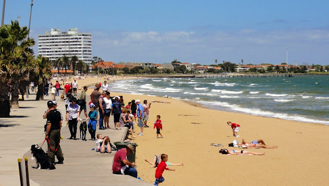
The town is predominantly fishing and tourism-driven. The main beach front is a harbour for commercial fishing and recreational watersport operations. The surf beach is patrolled by the Lakes Entrance Surf Life Saving Club. The waterfront is populated by the fishing fleet and two floating restaurants. The town's main residential areas lie farther inland. Lakes Entrance has a number of camping and caravan parks, and free camping spots in Colquhoun State Forest.

This post is part of the Travel Tuesday meme
and also part of the Roentare Water Meme.


Tuesday, 4 March 2025

WILSON'S PROM

Wilsons Promontory is a peninsula that forms the southernmost part of the Australian mainland, located in the state of Victoria, about 200 km southeast of Melbourne CBD. Coastal features include expansive intertidal mudflats, sandy beaches and sheltered coves interrupted by prominent headlands and plunging granite cliffs in the south, backed by coastal dunes and swamps. The promontory is surrounded by a scatter of small granite islands which, collectively, form the Wilsons Promontory Islands Important Bird Area, identified as such by BirdLife International because of its importance for breeding seabirds.

Wilsons Promontory is home to many marsupials, native birds and other creatures. One of the most common marsupials found on the promontory is the common wombat, which can be found in much of the park (especially around campsites where it has been known to invade tents searching for food). The peninsula is also home to kangaroos, snakes, wallabies, koalas, long-nosed potoroos, white-footed dunnarts, broad-toothed rats, feather-tailed gliders and emus. Some of the most common birds found on the promontory include crimson rosellas, yellow-tailed black cockatoos and superb fairywrens. There are also many pests, including hog deer, foxes, feral cats, rabbits, common starlings, and common blackbirds.

This post is part of the Travel Tuesday meme
and also part of the Roentare’s Water Meme.


Tuesday, 4 February 2025

INVERLOCH BEACH

Inverloch is a seaside village in Victoria, Australia. It is located on the Bass Highway 143 kilometres southeast of Melbourne, at the mouth of Anderson Inlet, in the Bass Coast Shire and is located close to Australia’s southernmost stand of mangroves. At the 2021 census, Inverloch had a population of 6,526 people.

Inverloch is a popular tourist destination, particularly for surfers, kitesurfers, windsurfers and fishers. The town hosts a jazz festival each Labour Day long weekend in March. Inverloch's amenities include a visitor information centre, two Pubs, three motels, seven bed and breakfasts, three caravan parks and a foreshore camping reserve.

Like most other Australian coastal towns Inverloch has a local surf lifesaving club. During 2005 and early 2006 the RACV built an eco-village holiday resort on the Cape Paterson Road near Inverloch. Inverloch is a popular holiday resort town for Melbournians and many of them have holiday houses here.

This post is part of the Travel Tuesday meme


Wednesday, 29 January 2025

FUN IN THE SUN, MORNINGTON

Mornington is a seaside town on the Mornington Peninsula, Victoria, Australia, located 57 km south-east of Melbourne's central business district. It is in the local government area of the Shire of Mornington Peninsula.

Mornington is known for its "village" atmosphere and its beautiful beaches. Mornington is a popular tourist destination with Melburnians who often make day trips to visit the area's bay beaches and wineries. The town centre runs into the foreshore area and local beach. Several conserved areas on the waterfront and hinterland preserve native flora and fauna.

Mornington is an attractive destination for shopping and features some excellent restaurants and cafes. The north of Mornington is also home to several horse breeders and stables. It has a modern library, cinema and numerous parks, gardens and historical buildings, many of which are open to the public. It holds several annual festivals, and holds a market day in the main street every Wednesday, which attracts hundreds of people.

Mornington has an active Yacht club (Mornington Yacht Club), located at Schnapper Point, catering for sailors of all levels and abilities, from beginners - “Tackers”, through to those competing at ocean racing level. The club hosts many state, National, & International regattas, as it provides a good location in sheltered, pristine waters. 2014 saw the successful running of the largest single class Yachting regatta ever held in the Southern Hemisphere - the Optimist National Championships. The Optimist is a youth class and drew over 2000 people to the Club and Mornington shire.

This post is part of the "Roentare’s Water Meme"

and also part of the Wordless Wednesday meme,

and also part of the Nature Notes meme


Monday, 27 January 2025

SUMMER DAY

We've had a typical Melbourne Summer day today: Overcast, muggy morning with a sudden semitropical downpour that refreshed the gardens. Then, the clouds disappeared, the sun started to climb in the sky and the heat intensified, reaching a high of 40˚C. Then, fortunately, in the evening a cool change rolled in and the temperature fell, with a more comfortable 22˚C now at night. The temperature is predicted to fall a few more degrees later tonight and a maximum of 22˚C tomorrow... Never a dull moment!

Needless to say, this being a long weekend (on account of Australia Day yesterday), the beaches were packed full of people seeking some relief and unfortunately, there a few spot fires around the City, with one of them at least suspected arson. Fortunately, no casualties and no houses lost. Thank you, Fire Brigade!

This post is part of the Mosaic Monday meme,
and also part of the Seasons meme.


Wednesday, 8 January 2025

SUMMER DAY

A perfect Summer's day today in Melbourne. And as I was stuck in the City, here are some archival photos of seaside vistas. Sigh...

This post is part of the Roentare’s Water Meme

and also part of the Wordless Wednesday Meme

and also part of the Nature Notes Meme

Fishing in Mornington

Brighton Bathing Boxes

Sandringham Beach

Williamstown Foreshore

Dromana Pier


Sunday, 29 October 2023

MORNINGTON BEACH

The Mornington Peninsula's rainbow-coloured bathing boxes have provided a colourful backdrop to countless swims and lazy beach days all along the coast of Port Phillip Bay. While technically no more than a shed, with no water or electricity, many of the historic bathing boxes have been passed down through generations and remain in high demand. Found on beaches from Mount Eliza and Dromana to Rosebud and Portsea, these iconic bathing boxes are the peninsula's symbol of summer and have become a tourist attraction in their own right.

This post is part of the My Sunday Best meme


Tuesday, 25 July 2023

PORT MELBOURNE BEACH

Port Melbourne is a suburb of Melbourne, Australia, 5 km south-west from Melbourne's Central Business District with the beach stretching along the top eastern end of Port Phillip bay. The beach is close to the CBD district and has excellent public transport access. Dotted with palm trees and wide open sandy beaches, this area is a favourite place for families to spend time.

South Melbourne and Port Melbourne Life Saving Clubs patrol the beach between the Kerferd Road and Lagoon piers. At both clubs you will find toilets, dressing rooms and kiosks. Port Melbourne Beach is one of the closest patrolled beaches to Melbourne city with the Beach Lifesaving Club situated on the foreshore along Beaconsfield Parade. Along this stretch of foreshore there is a low seawall and promenade. When waves are low the beach is quite safe to swim at, however it is advisable to stay on the sand bar and in the patrolled area in front of each club.

You can also surf when the southerly winds are high enough. At the end of each of the Kerferd Road and Lagoon piers you can fish as the waters are quite deep. To the east of Lagoon Pier the beach is quite narrow since the vegetated dunes occupy a large area and are fenced off. All along this area the sand dunes are being re-vegetated with native plants and it is appreciated that you walk on the designated tracks so as not to disturb the plantings.

This post is part of the Travel Tuesday meme


Tuesday, 16 May 2023

TWIN REEFS, INVERLOCH

Close to Inverloch, in Victoria's Southeast, is a secluded beach, called Twin Reefs.  Twin Reefs are two protruding, exposed reefs, in lee of which is a narrow, 500 m long, crenulate platform beach, lying between the base of the vegetated bluffs and the continuous intertidal rock flats. The Cape Paterson Road runs along the top of the bluffs and there is a car park and track down to the beach and rocks.

This post is part of the Travel Tuesday meme


Tuesday, 21 March 2023

INVERLOCH

Inverloch is a seaside village in Victoria, Australia. It is located on the Bass Highway 143 kilometres southeast of Melbourne, at the mouth of Anderson Inlet, in the Bass Coast Shire and is located close to Australia’s southernmost stand of mangroves. At the 2006 census, Inverloch had a population of 4,140.

Inverloch is a popular tourist destination, particularly for surfers, kitesurfers, windsurfers and fishers. The town hosts a jazz festival each Labour Day long weekend in March. Inverloch's amenities include a visitor information centre, two Pubs, three motels, seven bed and breakfasts, three caravan parks and a foreshore camping reserve. Like most other Australian coastal towns Inverloch has a local surf lifesaving club.

During 2005 and early 2006 the RACV built an eco-village holiday resort on the Cape Paterson Road near Inverloch. Inverloch is a popular holiday resort town for Melbournians and many of them have holiday houses here.


Tuesday, 26 April 2022

PHILLIP ISLAND, AUSTRALIA

Phillip Island is an Australian island about 140 km south-southeast of Melbourne, Victoria. Named after Arthur Phillip, the first Governor of New South Wales, Phillip Island forms a natural breakwater for the shallow waters of the Western Port. It is 26 km long and 9 km wide, with an area of about 100 km2. It has 97 km of coastline and is part of the Bass Coast Shire. The southern coast of the island lies exposed to the ocean of Bass Strait and can experience some wild weather, which doesn't seem to deter avid surfers.

This post is part of the Travel Tuesday meme,


Tuesday, 15 February 2022

NINETY MILE BEACH

The Ninety Mile Beach is a sandy stretch of beach on the south-eastern coastline of the East Gippsland region of Victoria in Australia. The beach faces Bass Strait and backs the Gippsland Lakes. The beach is just over 151 kilometres (94 mi) in length, running north-eastward from a spit near Port Albert to the man-made channel at Lakes Entrance. Behind the beach are long sandy dunes that separate the Gippsland Lakes from Bass Strait. 

The beach is an uninterrupted stretch of untamed coastline; it does not have any rocky headlands or platforms, and offshore there are only a few ribbons of reef which are periodically covered by sand. In the northern section, the beach runs along a sandbar on what amounts to a series of tidal islands. Behind this are several large lakes and numerous shallow littoral lagoons. The three main lakes are Lake King, Lake Victoria and Lake Wellington, partially contained within The Lakes National Park.

This post is part of the Our World Tuesday meme,
and also part of the Blue Monday meme,
and also part of the Travel Tuesday meme,
and also part of the Wordless Wednesday meme.


Tuesday, 25 January 2022

ST KILDA

Summer, sea, sand and St Kilda Beach in Melbourne. St Kilda is an inner suburb of the metropolitan area of Melbourne, Victoria, Australia, 6 km south-east of Melbourne's Central Business District. Its local government area is the City of Port Phillip. At the 2011 Census, St Kilda had a population of 17,795. St Kilda was named after a schooner, Lady of St Kilda (which moored at the main beach for much of 1841) by Charles La Trobe, and the ship's master and early settler Lieutenant James Ross Lawrence.

During the Victorian and Edwardian eras, St Kilda became a favoured suburb of Melbourne's elite, and many palatial mansions were constructed along its hills and waterfront. Shortly after the turn of the 20th century, St Kilda served a similar function for Melburnians as did Coney Island to the residents of New York City and its history draws an interesting parallel. St Kilda is home to many of Melbourne's famous visitor attractions including Luna Park, the Esplanade Hotel, Acland Street and Fitzroy Street.

It is home to St Kilda Beach, Melbourne's most famous beach, several renowned theatres and several of Melbourne's big events and festivals. Considering its popularity and the large number of visitors, St Kilda beach is quite clean and well-looked after.

This post is part of the Our World Tuesday meme,
and also part of the Ruby Tuesday meme,
and also part of the Travel Tuesday meme,
and also part of the Wordless Wednesday meme.


Tuesday, 12 October 2021

DROMANA

Dromana is a suburb south of Melbourne, and is located on the Mornington Peninsula. Its local government area is the Shire of Mornington Peninsula. It is a bayside centre, nestled between Safety Beach and McCrae, and situated at the foot of the towering peak of Arthurs Seat. Dromana's commercial centre is concentrated along the coastal boulevard of Point Nepean Road, with Arthurs Seat and its surrounding bushland providing a scenic backdrop to the shops and cafes along this route.

Dromana's foreshore reserve lines the coast and consists of grassy picnic areas, shelters, walking tracks and designated camping areas. The calm, sandy beaches provide safe swimming and boating opportunities. Points of interest along the coast include the Dromana Pier and the rocky cutting at Anthony's Nose where a boat ramp is situated.

This post is part of the Our World Tuesday meme,
and also part of the Ruby Tuesday meme,
and also part of the Travel Tuesday meme,
and also part of the Wordless Wednesday meme.


Tuesday, 29 September 2020

DROMANA BEACH

Dromana is a suburb south of Melbourne, and is located on the Mornington Peninsula. Its local government area is the Shire of Mornington Peninsula. It is a bayside centre, nestled between Safety Beach and McCrae, and situated at the foot of the towering peak of Arthurs Seat. Dromana's commercial centre is concentrated along the coastal boulevard of Point Nepean Road, with Arthurs Seat and its surrounding bushland providing a scenic backdrop to the shops and cafes along this route.

Dromana's foreshore reserve lines the coast and consists of grassy picnic areas, shelters, walking tracks and designated camping areas. The calm, sandy beaches provide safe swimming and boating opportunities. Points of interest along the coast include the Dromana Pier and the rocky cutting at Anthony's Nose where a boat ramp is situated.

This post is part of the Our World Tuesday meme,
and also part of the Ruby Tuesday meme,
and also part of the Travel Tuesday meme,
and also part of the Wordless Wednesday meme.